This is for Mary and Don – what I have found is, in good part, because of your kind help.
This is about the odd land business that is associated with the name Charles Snead/Sneed. I cannot tell which spelling is the one favored by the man himself, but it looks as though he does sign the bottom of one of the grants himself. This is slightly unusual, considering the fact that so many of the documents I have been dealing with during the late seventeen hundreds and the early eighteen hundreds are signed by mark.
So if he DID sign it, he spelled the name SNEAD, and he was literate enough to do that neatly. This is all very confusing. When I read about the Accomack Snead family, I run almost exclusively into that spelling. But in North Carolina, some of whom came from Accomack and environs, the spelling runs to our own, and that which is used in Washington County. The newspapers use Sneed and so do the census takers, for the most part. The grant papers are ambivalent.
Don has evidently pulled the original grant papers from the Archives. Many of these I had already skimmed from the FHL films. He did find one that should have been in that collection, but wasn’t.
These plats and grants show neighbor’s names and associated names, some of which can be found in the newspaper clippings from the 20s on – like Morgan Brown and Joseph Session, the Fish family and others. But other names like John Grantham and Thomas Jones do not show up in the papers or in the later census (by which, I mean 1820 and on). It would stand to reason that men who left civilization in order to make a new life would not be all that adverse to moving on again.
Another problem here is that Washington County, in 1784, was a huge mass of Indian lands, a thin, sloping column that would later be broken into some eight other counties. Hancock, immediately to the north of the present county. So identifying water courses in the plats is very important. A man could appear to be a resident of Washington County during that period, but within twenty years appear to have moved himself through two or three counties – when his farm is in the exact place it always was.
Which is why I take the Sneed evidence so seriously. The watercourses indicated in the early plats (1789-1797) suggest that Charles Sneed – if there was only one of them, which I am beginning to doubt – had his interest in exactly the same place that Sarah and Ansel were still living in 1820, and that the triangle made by Keg/Cag creek and the Ohoopie also included Anderson and William Sneed.
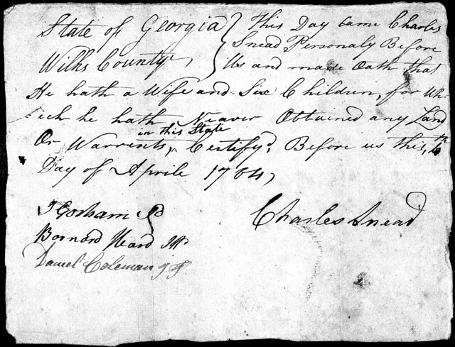
To start from the beginning: With a man named Charles Snead who has a wife and six kids, taking an oath that there has never been head right awarded to any of these people in this state (which detail seems important, as it was carefully added after the fact). April 1784.
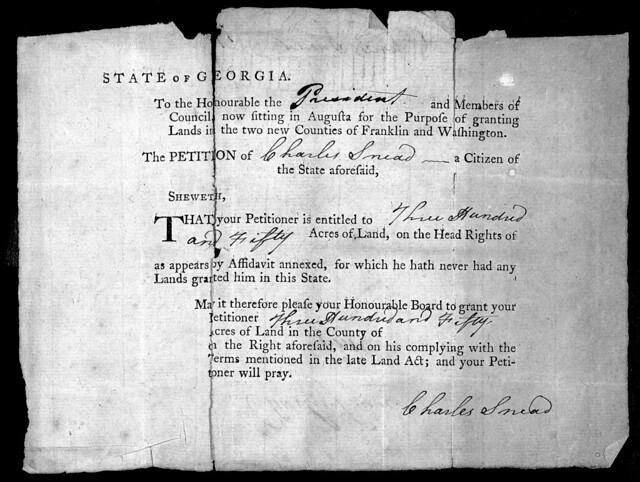
The deal was 50 acres for each person you brought into the newly opened lands and 200 acres for you, yourself, as a serious settler. The following petition, which is not dated, front nor back, but seems connected stipulates no county.
The earliest records we have found of this Charles actually having fiduciary responsibility for land ANYWHERE is this 1785 Wilkes, GA property tax return. It’s interesting to me that, if the rest of his family were to be awarded head rights, the tax is just under his name. Then again, a woman and six children – who all were evidently minors, as none of them seems to have been awarded under his own name – weren’t really considered active citizens in those days – unless they were orphans or widows.
In this tax return, Charles is charged tax for 200 acres in Wilkes County – which would be the head of household number of acres-for-self. But another 400 acres in Franklin County, which was also (as was Washington County) created in 1784. So this is 600 acres, which is more than the 550 acres you might expect for a Man who has wife and six children.
Now here is a thing I do not understand, and have to ask Mary. What do the columns mean? There are three columns under which acres are numbered. All of Charles’ land is in the second column. There are no watercourses denoted in this return, nor adj properties. He is in Captain Pope’s district.

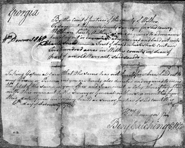
In 1786, in Wilkes County, a directive is given to survey and plat 200 acres in Wilkes County, in lieu of part of an old Warrant (said Sneed):
And there is a 1786 tax return.
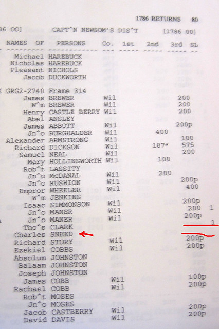
But there is NO acreage on it. I don’t understand the “SL” column either. So – it seems that he is a resident of the county, or he wouldn’t be listed in the return, is that right? And the 600 acres has disappeared. Sold? Or not claimed?
We don’t have any records for him, there were none in the Hudson book that covers all the tax returns in Wilkes, in 1787 or 1788. I do not know, I just realize, whether there were returns that survived for those years, or if Charles simply didn’t show up in them.
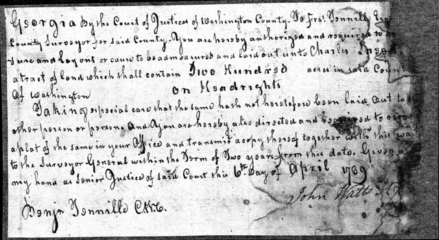
But in 1789, we have a huge shift. Suddenly, Charles’ name shows up in Washington County. We have two documents: a direction to the surveyor to so admeasure 200 acres in Washington County on headright and a plat in Washington County.
And we have actual plats of this land. For the first time that we can find. The 1789 plat is included in both The Surveyor Records Book D-E pg 100 (97) (several numbers for each page), and in the collection of original grant paper work. Each one is slightly different.
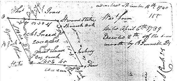
On the first, the one in the Surveyor’s Book, Cag (Keg) creek is clearly marked, flowing through the property on the diagonal. I wish I could read all the details here, because there are two creeks. Also, they aren’t giving me much of a NS orientation.
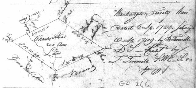
The one above here is the same land, the plat kept in the formal plat drawers. It has a different orientation on the page, but I still don’t know where North actually is. Both, as you will note, show Jones and Grandtham on the left and top, Vacant land on the right and bottom. This is about to become important.
Now, my dear detectives, is another little mystery for us. And this one nearly chokes me: on pg. 50 of this D-E book (the lower corner number) we find this crazy little gem:
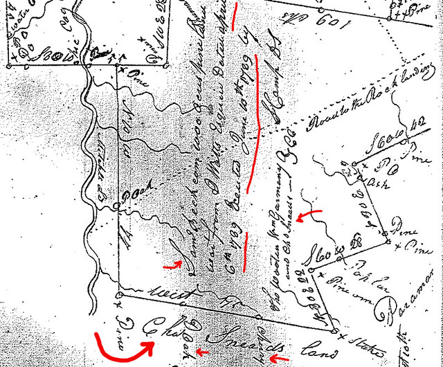
This land was written up and then executed on exactly the days written on Charles’ plats above – april and June 1789. And what you are looking at is a 1000 acre grant for Samuel Becham. Please note that Cag (Keg) Creek runs parallel to the Northern border of this land (YAY, someone wrote west here). And that Charles Snead’s land abuts Sam’s land to the west.
This is a huge deal. Because Charles’ own 200 acre plat DOES NOT ABUTT Samuel Beacham. Also, Charles’ 200 acre plat does not indicate Cherry or Oak. So this looks to me like ANOTHER piece of land that belongs to Charles Snead. NOT THE ONE WE SEE PLATTED. Also, it does look particularly as if Cag Creek runs THROUGH this land. It also looks as though it’s possbible that Paramor might also adjoin Snead’s land.
Another detail on this plat is the fact that the chain carriers (who aid in the surveying and measuring of the land) were THOMAS WOOTEN, William Garmany?, and CHARLES SNEED. (we’re getting both spellings on this plat). This means that Charles Snead not only was granted land in Washington county, but he walked on the ground here, and had neighbors with whom he was willing to work.
But wait – it gets weirder. SO MUCH WEIRDER. Holy CATS.
1791: Two years LATER, here is a grant for Charles Sneed – 200 acres in the county of WILKES:
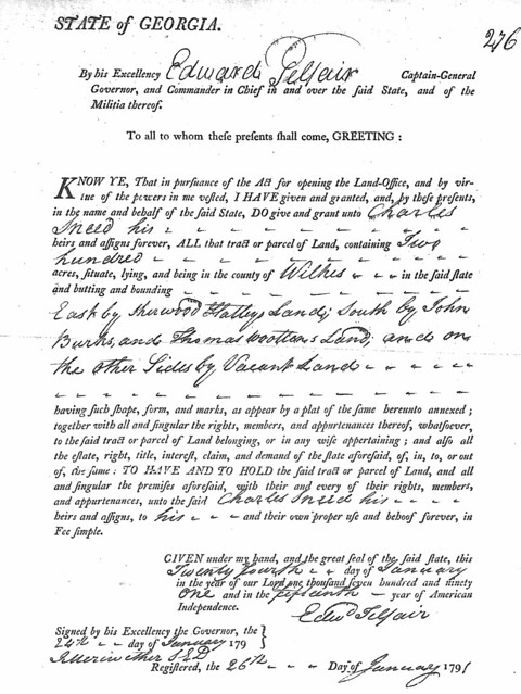
BUT LOOK AT THE NAMES of the adjoining lands: East by Sherwood Glattey? Hattley?, South by John Burkes and Thomas Wooten’s Land. Burke is a new name to us, that we’re about to see again. But Thomas Wooten is the man who was chain carrier with Charles Snead in Washington, which seems to me to be as near a proof of ANYTHING in this mystery than I have yet had. And the name Sherwood, here, is interesting to me in that it might indicate where Sherrod Sneed who was a minor in Washington County in 1820, might have been named for.
AND WE SWING BACK AGAIN to Washington County with two more grant papers for the same 200 acres we saw platted on the Cag in Washington County in 1789. These are dated 1794 and 1797:
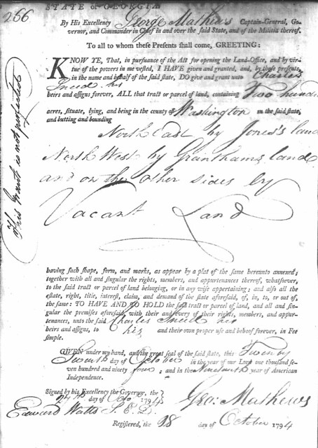
This one has the odd note to the side: “This grant not perfected,” which is an indication that the fees associated with this grant, or the interest on them, have not been fully paid. You will note no mention of Beacham as a neighbor here.
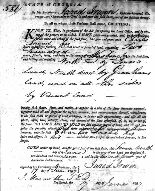
This is exactly the same grant. The third time it’s been put to paper.
There is an end to this part of the story. I don’t have images of the deeds, but in Hancock County, which was part of the original Washington County, GA, and finally created just to the north of the present Washington County (sharing a border) we find two deeds, or really a chain of title that I have in my notes as follows:
— Hancock County deeds, Book E pg 336 and pg 337: (I found and read these today, July 14, 2015, after months of trying to find the right FHL film – 222???-, and then the right page. My copy of Elizabeth Newsom’s cards left the 6 off the end of the page number.)
Pg. 336: An indenture between Nathaniel Fulton of Hancock, Ga and William Sanders of Washington County, who is buying. 200 acres in Hancock Count, lying more or less on the waters of Keg Creek bnd to NE by Jones and on the NW by Granthams and on all sides vacant at the time of Survey. (Post Oak is the beginning of the description). This tract is the same land granted to Charles Sneed bearing the date 17 June, 1797. Doc witnessed by James Sanders, Benjamin Bryant, Wm Gilliland JP Nov 1801 sales price $400
Pg. 337: An indenture between William Herndon and Nathaniel Fulton who is buying. Fulton pays $236 for the above piece of land (this deed is earlier, but recorded the same day as the above) Same land, as granted to Charles Sneed (the name is VERY clearly written in this one) on the same date given above. This transaction done 18 March 1800 and wit. By Abram Cook.
There is an additional note concerning Benjamin Bryant’s witness of the above transaction, dated 13 Aug 1801, signed by Wm Gilliand JP This assurance proven Nov 24 1801.
Thus we can see clearly that this particular bit of land, through 1797, never bordered on anyone BUT Jones and Grantham. No mention of Beacham.
We’re going to switch back to WILKES one last time, not because CHARLES switched back, but because his name appears in the property tax registers for 1797 ONLY as the grantee on lands that have since changed hands: three pages of property tax returns in Wilkes County, Ga for 1797; not as property owner. I don’t see poll tax either. I think he just was no longer there at all.
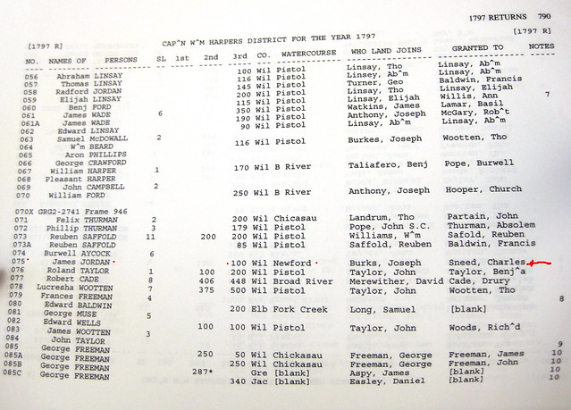
In the page above (and remember all three pages are all the same year, and the same year as the final grant on Keg Creek of that 200 acres in Washington county) we find the name of Thomas Wooten as grantee a couple of times on land by Pistol Creek. About a third of the way down, you can see the name BURKES again, this time Joseph Burkes, adj to the Land that Wooten once owned, but is now owned by Wm Beard. Lower, we see hat Joseph Burkes is also adj. to land once granted to Charles Sneed, on Newford Creek (100 acres). A bit further down, we see that Wooten was grantee on the Pistol of 500 acres now belonging to Lucresha Wooten. (I have to figure out what col SL, 1st, 2nd, 3rd mean)
Here, let me explain that the watercourse associated with Charles’ land, Newford Creek, flows out of SC, in the far north easter bit of Wilkes County, far, far from Keg Creek in Washington county, so we are not looking at lands that were anywhere near each other. And Pistol Creek, which you see above, is north of Newford, parallel to it.
You can see that these property tax records can give you a lot of hints about relationships and proximity, if you milk them well. There are several records for Snead/ Sneed in Hudson’s compendium of these property taxes. Some are without given name. Under Snead we find John, Charles and Dudley. Under Sneed, we find much more – entries for Charles, Dudley, John – also Zach and Samuel. I will have to go back into these records to study the locations of the land of each of these people.
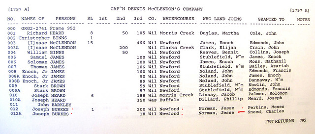
On the page above, we see several pieces of land on the Newford. At the bottom, Joseph Burkes now owns 18 acres that were part of the Charles Sneed grant, adj to Jesse Norman (and there’s more story to that if you look at it closely).
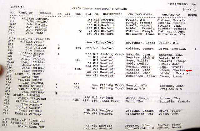
On the page above, here, there’s more to learn about the community. Charles Sneed is grantee on land adj to John Witteck on the Newford – 100 acres now belonging to Pearman. Francis Baldwin’s name shows up in this area several times, too. It is my experience that getting a feel for a neighborhood of people leads you to discoveries.
So these tax records show us a connection between Washington and Wilkes, Charles Snead and Thomas Wooten. So it’s possible that both men owned in both counties; certainly both seem to be out of Wilkes by leaving or dying by 1797. Or we could be seeing two name-sake sons breaking off from their Wilkes family and moving down into Washington County.
I think what’s going to have to happen now is a dive into the Wilkes deeds and probates to see what can be found there. I’m not going to find anything about this land in Washington because there are no deeds or probates there till after 1868 or so, thank you General Sherman. But I’ve got some stuff on the Sneeds who show up in Washington from 1805 through the 1830s, so there is a story here.
I guess I need to add this, too. One of the later Sneeds, Anderson – his family ended up heading for Florida and a cousin is tracking them. There’s a family legend down there about how Charles Sneed, who was remembered as a brother to Anderson Sneed, sold up his land in Washington County and went to Texas. And that he came back to Georgia to visit in Feb of 1830. If this is true, it looks like there might have been two Charles – perhaps the original Charles, who would have been well into his 30s in 1784 (and I’m not really seein’ a guy who is 76 years old hauling himself from Texas back to Georgia in those days) had a son named Charles. And maybe the original Charles never cashed in on the headright for each of his kids, and his son, Charles, took his OWN headright in Washington County? Maybe with three of his brothers? But that’s another file altogether.